Museums preserve clues that can help scientists predict and analyze future pandemics

Pamela Soltis

Distinguished Professor and Curator, Florida Museum of Natural History, University of Florida

Joseph Cook

Professor of Biology and Curator, Division of Mammals, Museum of Southwestern Biology, University of New Mexico

Richard Yanagihara

Professor of Pediatrics and Principal Investigator, Pacific Center for Emerging Infectious Diseases Research, University of Hawaii

24 June 2020  8.17am EDT

***

In less than 20 years, communities around the globe have been hit by a string of major disease outbreaks: SARS, MERS, Ebola, Zika and now, COVID-19. Nearly all emerging infectious diseases in humans originate from microorganisms that are harbored by wildlife and subsequently “jump,” either directly or indirectly – for example, through mosquitoes or ticks – to humans.

One factor driving the increase in zoonotic disease outbreaks is that human activities – including population growth, migration and consumption of wild animals – are leading to increased encounters with wildlife. At the same time, genetic mutations in viruses and other microbes are creating new opportunities for disease emergence.

But humans remain largely ignorant of our planet’s biodiversity and its natural ecosystems. Only two million species – about 20% of all the estimated species on Earth – have even been named. In our view, this fundamental ignorance of nearly all aspects of biodiversity has resulted in an inefficient, poorly coordinated and minimally science-based response to key aspects of the COVID-19 pandemic.

We have diverse backgrounds in plant and mammal evolution and emerging infectious diseases. In a newly published commentary that we wrote with colleagues from across the U.S. and in six other countries, we identify a largely untapped resource for predicting future pandemics: natural history collections in museums around the world.

These collections preserve specimens of animals, plants and other organisms that illustrate the diversity of life on Earth. They are reservoirs of information and samples that can help scientists identify likely pathogen sources, hosts and transmission pathways. We believe that leveraging collections in this way will require more resources and more collaboration between biodiversity scientists and disease outbreak sleuths.

Sir David Attenborough explains how museum collections contribute to our understanding of the natural world.

Archives of life on Earth

Research shows that zoonotic diseases have increased due to human intrusion into animal habitats. In particular, destruction of tropical rain forests throughout the world has brought us face to face with microbes that occur naturally in wild animals and can cause disease in our own species.

Earth’s biodiversity is connected through a family tree. Viruses, bacteria and other microbes have evolved with their hosts for millions of years. As a result, a virus that resides in a wild animal host such as a bat without causing disease can be highly pathogenic when transmitted to humans. This is the case with zoonotic diseases.

Unfortunately, national responses to disease outbreaks are often based on very limited knowledge of the basic biology, or even the identity, of the pathogen and its wild host. As scientists, we believe that harnessing centuries of biological knowledge and resources from natural history collections can provide an informed road map to identify the origin and transmission of disease outbreaks.

These collections of animals, plants and fungi date back centuries and are the richest sources of information available about life on Earth. They are housed in museums ranging from the Smithsonian Institution to small colleges.

Together, the world’s natural history collections are estimated to contain more than three billion specimens, including preserved specimens of possible hosts of the coronaviruses that have led to SARS, MERS and COVID-19. They provide a powerful distribution map of our planet’s biodiversity over space and through time.

Preserved pathogens

How can researchers channel these collections toward disease discovery? Each specimen – say, a species of pitcher plant from Florida or a deer mouse from arid New Mexico – is catalogued with a scientific name, a collection date and the place where it was collected, and often with other relevant information. These records underpin scientists’ understanding of where host species and their associated pathogens are found and when they occurred there.

Connecting the site of a disease outbreak to potential pathogen hosts that occur in that area can help to pinpoint likely hosts, sources of pathogens, and pathways of transmission from hosts to humans and from one human to another. These natural history collections are connected worldwide through massive online databases, so a researcher anywhere in the world can find information on potential hosts in far-off regions.

But that’s just the beginning. A preserved specimen of a rodent, a bat or any other potential host animal in a collection also carries preserved pathogens, such as coronaviruses. This means that researchers can quickly survey microbes using specimens that were collected decades or more before for an entirely different purpose. They can use this information to quickly identify a pathogen, associate it with particular wild hosts, and then reconstruct the past distributions and evolution of disease-causing microbes and hosts across geographic space.

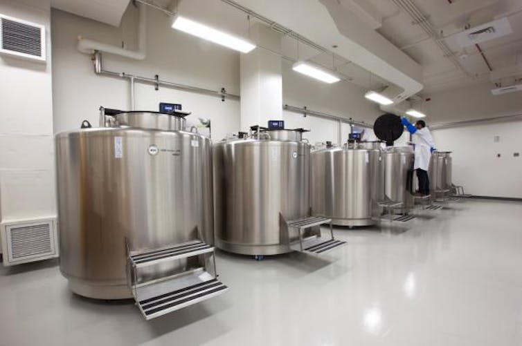
Many collections contain frozen samples of animal specimens stored in special low-temperature freezers. These materials can be quickly surveyed for microbes and possible human pathogens using genetic analysis. Scientists can compare DNA sequences of the pathogens found in animal specimens with the disease-causing agent to identify and track pathways of transmission.

Nitrogen freezers for cryo-preserving specimens in the Smithsonian National Museum of Natural History’s Biorepository. Donald E. Hurlbert/SmithsonianCC BY-ND

For example, museum specimens of deer mice at the University of New Mexico were key to the rapid identification of a newly discovered species of hantavirus that caused 13 deaths in the southwest United States in 1993. Subsequent studies of preserved specimens have revealed many new species and variants of hantaviruses in other rodents, shrews, moles and, recently, bats worldwide.

Equipping museums and connecting scientists

Natural history collections have the potential to help revolutionize studies of epidemics and pandemics. But to do this, they will need more support.

Even though they play a foundational role in biology, collections are generally underfunded and understaffed. Many of them lack recent specimens or associated frozen tissues for genetic analyses. Many regions of our planet have been poorly sampled, especially the most biodiverse countries near the tropics.

To leverage biodiversity science for biomedical research and public health, museums will need more field sampling; new facilities to house collections, especially in biodiverse countries; and expanded databases for scientists who collect the samples, analyze DNA sequences and track transmission routes. These investments will require increased funding and innovations in biomedical and biodiversity sciences.

Another challenge is that natural history curators and pathobiologists who study the mechanisms of disease work in separate scientific communities and are only vaguely aware of each other’s resources, despite clear benefits for both basic and clinical research. We believe now is the time to reflect on how to leverage diverse resources and build stronger ties between natural history museums, pathobiologists and public health institutions. Collaboration will be key to our ability to predict, and perhaps forestall, future pandemics.

***

Pamela Soltis, Joseph Cook, Richard Yanagihara

Museums preserve clues that can help scientists predict and analyze future pandemics

first published in “The Conversation” under a Creative Commons license

your money, your life, your choice | California, cars, CO2

California, in so many ways, could learn from the US Northeast. 

To reduce CO2 and and greenhouse gas emissions from cars, a continuing and increasing issue in California and elsewhere, cities need data—ways to accurately measure emissions, pinpoint sources, and monitor change over time; cities need to know how much CO2 they are producing and reducing.

A tool called ACES (Anthropogenic Carbon Emissions System) was developed in response to the requirement for data by researchers at Boston University and Harvard. ACES offers finely-grained maps of CO2 emissions, with a resolution of 1km2, totaled hourly.

As we know, per our atmosphere – the air, its particular mix of gaseous elements, and its temperatures, together vital to life, inclusive of human, animal, and plant – CO2 and other greenhouse gases are an issue, in many ways.

California has “targets” to meet by the year 2020 for limiting the greenhouse gases associated with the driving that people do on a daily basis. The approach to greenhouse gases associated with the driving that people do on a daily basis has a heightened level of complexity in California. Driving a car, rather than availing oneself of public transportation such as a subway, metro, or bus, is a norm that people are highly unwilling and actually afraid to examine and rethink. The many localities within the state have made limited investment in public transportation in significant part because taking such modes of transportation is largely considered to be beneath the dignity – whether personal, social, or professional – of and compromising to anybody with a sense of self esteem.

While the “hope” has been that climate emissions might be curbed largely by promoting regional planning of denser development along transit lines ( S.B. 375, the Sustainable Communities and Climate Protection Act, a landmark 2008 deal, with the California legislature recognizing the critical role of integrated transportation, land use, and housing decisions to meet state climate goals), the California Air Resources Board 2018 Progress Report released in November documents that driving of cars has skyrocketed statewide during the years following the recession of 2008 – 2009 through 2016.

A “key finding of this report is that California is not on track to meet the greenhouse gas reductions expected under SB 375 for 2020, with emissions from statewide passenger vehicle travel per capita increasing and going in the wrong direction” (page 4) and “emissions from the transportation sector continuing to rise despite increases in fuel efficiency and decreases in the carbon content of fuel” (page 5).

Top air quality officials in California state they currently have no way to fully assess whether regions from San Diego to Sacramento are on track to meet 2020 targets for reigning in greenhouse gases associated with daily driving. While “greenhouse gas emissions considered under the SB 375 program reflect carbon-dioxide (CO2) emissions only from light-duty passenger vehicles” (page 21, footnote 22), the California Air Resources Board 2018 Progress Report states, “SB 375 passenger vehicle greenhouse gas emissions reductions cannot be directly measured because greenhouse gas emissions come from many sources” (page 21).

Air board officials said that while they tracked the key metric of vehicle miles traveled, or VMT, available statewide through fuel sales, that same information wasn’t available regionally. Without that, officials say there is no consistent way to extrapolate greenhouse gas emissions from driving for each region.

There’s no unifying way to bring it all together and say ‘You’re at this particular performance metric,’” said Nicole Dolney, chief of the air board’s transportation planning branch. “Our hope was that we would have VMT data that we could rely on, but it wasn’t there.”

So what might California learn from ACES?

For cities to cut down CO2, they need to know how much they are producing and reducing. Most cities get rough estimates with “carbon calculators” that account for the size and population of a city, electricity used, and an estimate of how many cars zip (or crawl) through the city streets.

“The calculation would be fine except for all those cars. Cars are the hardest part of the emissions equation to quantify. They are moving all the time at different speeds, and there are different cars on the road at different times of day.”

“There are other factors to consider. There’s the make of the car, of course: a Toyota Prius gives off less CO2 than a Chevy Silverado. There’s also the speed; most cars give off the least CO2 when cruising in a “sweet spot” between 40 and 60 miles per hour.”

(Conor Gately, co-developer of ACES; PhD, Geography and Environment, Boston University, 2016; lead author on a study examining cities, traffic, and CO2, published in the Proceedings of the National Academy of Sciences (PNAS) in April 2015.)

ACES (Anthropogenic Carbon Emissions System) has been developed by Lucy Hutyra of Boston University and Conor Gately, now a postdoctoral associate working jointly at Boston University and Harvard. A tool for measuring and mapping CO2 emissions, ACES offers finely-grained maps of CO2 emissions, with a resolution of 1km2, totaled hourly, is relevant and could be helpful to the cities and the state of California.

Cities have the political will to change emissions, and they have policy levers to pull,” says Lucy Hutyra, a Boston University College of Arts & Sciences (CAS) associate professor of Earth and environment. And because cities are responsible for 70 percent of greenhouse-gas emissions, according to the United Nations, their actions matter. But to take effective action, cities need data—ways to accurately measure emissions, pinpoint sources, and monitor change over time. And so Hutyra and her colleague Conor Gately have developed a tool called ACES, for Anthropogenic Carbon Emissions System, that offers the finest-grained maps of CO2 emissions in the Northeastern US to date, with a resolution of 1km2, totaled hourly. The tool, funded by NASA’s Carbon Monitoring System and detailed in the October 12, 2017, issue of the Journal of Geophysical Research—Atmospheres, could provide valuable data to cities nationwide.

‘The goal was to take the finest grained, most local data possible and build a ‘bottom-up’ inventory,” says Gately. The research team started by divvying up the sources of emissions on a giant whiteboard. “We did every sector of emissions of CO2,” he says. “Roads, residential buildings, commercial buildings, industrial facilities, power plants, airports, marine ports, shipping, and railway.” The group searched for data from 2011, scouring every source they could find: city and country records, household fuel estimates, EPA databases, hundreds of traffic sensors located around New England. All of these data, when combined with the amount of fossil fuels consumed in the region (gasoline, diesel, home heating oil, coal and natural gas for power generation), allowed the team to calculate CO2 emissions for all of the major sources. The team then calculated emissions for every hour of the year.

Gately, working with a three-year, $1.5 million grant from the National Oceanic and Atmospheric Administration, is now expanding ACES to cover the entire continental United States and meeting with government, scientific, and policy stakeholders to help create a core set of methods and data products.”

DARTE might also be helpful. DARTE, the Database of Road Transportation Emissions (Conor Gately, Lucy Hutyra, Ian Sue Wing) is available for free download from the Harvard Dataverse

Funded by grants from the National Aeronautics and Space Administration (NASA), the National Science Foundation (NSF), and the Department of Energy (DOE), Gately has developed a more precise way to tally CO2 emissions from vehicles. He used 33 years of traffic data to build the Database of Road Transportation Emissions (DARTE), which displays CO2 data for the contiguous US on a finer scale than ever before—a one-kilometer grid. (He hopes to add Alaska and Hawaii later.) Available for free download, DARTE could change the way cities and states measure greenhouse gas emissions.

The science is coming together to bring us very fine measurements in a way never possible before,” says Lucy Hutyra, an assistant professor of earth and environment and a coauthor on the PNAS study. Hutyra says that DARTE complements NASA’s Orbiting Carbon Observatory 2, which is collecting global data on atmospheric carbon dioxide. “We need good bottom-up data to match what we’re measuring looking down from space. That’s what we need to really advance greenhouse gas policies.”

See:

2018 Progress Report: California’s Sustainable Communities and Climate Protection Act,” California Air Resources Board, November 2018

Regions across California likely off the hook for 2020 caps on greenhouse-gas emissions from driving,” Joshua Emerson Smith, The San Diego Union-Tribune, 27 November 2018

Poor forest management: Trump oversimplifies state’s fire problem,” Readers React, The San Diego Union-Tribune, 20 November 2018

A Fine-Tuned Map for CO2,” Barbara Moran, Boston University Research, 26 October 2017

A New Map for Greenhouse Gas,” Barbara Moran, Boston University Research, 10 April 2015

Gately, Conor, K.; Hutyra, Lucy, R.; Sue Wing, Ian, 2015, “Cities, traffic, and CO2: A multi-decadal assessment of trends, drivers, and scaling relationships“, https://doi.org/10.7910/DVN/28999, Harvard Dataverse, V6


art, real estate, luxury, & global risks

“Humanity has become remarkably adept at understanding how to mitigate conventional risks that can be relatively easily isolated and managed with standard risk-management approaches. But we are much less competent when it comes to dealing with complex risks in the interconnected systems that underpin our world, such as organizations, economies, societies and the environment.

“There are signs of strain in many of these systems: our accelerating pace of change is testing the absorptive capacities of institutions, communities and individuals.

“When risk cascades through a complex system, the danger is not of incremental damage but of “runaway collapse” or an abrupt transition to a new, suboptimal status quo.”

See: “The Global Risks Report 2018, 13th Edition” | World Economic Forum (WEF); Strategic Partners: Marsh & McLennan Companies, Zurich Insurance Company; Academic Advisors: National University of Singapore, Oxford Martin School, University of Oxford, Wharton Risk Management and Decision Processes Center, University of Pennsylvania

#art #artmarket #collectionsmanagement #data #analytics #risk #riskanalysis #riskmanagement #riskmitigation #climaterisk #insurance #insurancerisk #realestate #commercialrealestate #culturalrealestate  #culturalheritage #luxury #resilience #CO2

HouseZero ・retrofitting a 1924-era wood-frame house

Harvard University’s Center for Green Buildings and Cities, in collaboration with international architecture and design firm Snøhetta, is retrofitting a wood frame house built in 1924 in what is now an historic district of Cambridge, Massachusetts. The house now serves as the Center’s headquarters.

The retrofit is intended to fulfill multiple objectives:

A focus on inefficient existing buildings. In the United States, buildings consume around 40% of energy produced annually. This equates to more than $230 billion spent annually by property owners heating, cooling, and powering the nation’s 123.6 million homes. Housing consumes 18-23% of that.

A focus on using current technologies together with better design.

The use of zero energy for heating and cooling. A retrofitted building that produces more energy than it consumes.

100% natural ventilation and daylight autonomy

Zero CO2 emissions, including embodied energy in materials

A positive rather than a negative impact on the surrounding environment. A house conducive to occupant health, encouraging productivity and creativity.

Use of self-generated data that will allow the building to self-adjust. The house will adjust itself seasonally and daily to achieve thermal comfort targets.

The development of ideas and a working model that can be used by homeowners as they seek to renovate existing houses towards significant energy and carbon use improvements without costly or wasteful tear-downs.

The Center for Green Buildings and Cities will not seek any kind of independent certification, such as USGBC LEED, WELL, or Living Building certification. The intent is, rather, to exceed those standards’ criteria.

The renovation, says Ali Malkawi, professor of architectural technology and founding director of the CGBC, is guided not only by the goal of net zero energy consumption with 100% natural light and ventilation but also by the understanding that a green building is “a sustainable building, which means it has the lowest impact on its surrounding environment as possible. It might have a positive effect on its environment—the surrounding as well as the global.” Such a building is, furthermore, “healthy for its occupants” and encourages productivity and creativity.

See:

Harvard Center for Green Buildings and Cities unveils HouseZero project, an ambitious retrofit of its Cambridge headquarters” | Travis Dagenais, Harvard Graduate School of Design, 25 May 2017

Harvard’s ‘HouseZero’” | Alisha Ukani, Harvard Magazine, 3 August 2017

Future Home: HouseZero” | Harvard Center for Green Buildings and Cities”

#architecture #architecturaltechnology #buildingtechnology #technology #design #engineering #netzero #energy #resilience #CO2 #home #luxury #smartluxury #retrofit #homeownership #realestate #commercialrealestate #culturalrealestate #culturalheritage #art #collectionsmanagement #museums #galleries #snøhetta #harvard #harvardcenterforgreenbuildingsandcities #Cambridge #data #health #wellness #family

Denver tracks & publicly reports annual commercial & multi-family building energy performance data

A city ordinance adopted by the Denver City Council in late 2016 requires commercial and multi-family buildings of 25,000-square-feet and over to track and publicly report their annual energy performance.

The deadline for property owners of larger buildings (50,000+ square feet) to file 2016 energy benchmarking reports is June 1. There is a city 90-day grace period for filing, ending on September 1.

Owners of smaller buildings, of 25,000 – 50,000 square-feet, are required to file their energy performance reports by June 2018.

According to the city, 57 percent of Denver’s greenhouse gas emissions are generated by large commercial and multifamily buildings.

Katrina Managan, Senior Advisor, Energy Efficiency, Denver Department of Environmental Health, reports that ”there are approximately 2,400 buildings over 50,000 square feet that need to comply this first year.”

The city of Denver plans to publish building energy performance data annually.

See:

$2,000 penalty looms for Denver building owners who don’t say how much energy they’re using” | Adrian D. Garcia, Denverite, 11 July 2017

Colorado signs on to U.S. Climate Alliance, joining states committed to exceeding Trump’s rejected Paris climate targets” | Bruce Finley, Denver Post, 11 July 2017

Denver Imposes $2,000 Fine for Building Owners Who Don’t File Energy Benchmarking Reports” | Emily Holbrook, Energy Manager Today, 12 July 2017

#realestate #commercialrealestate #greenhousegasemissions #commercial #multi-family #energyefficiency #buildingenergyperformance #data #Denver #Colorado

a ‘mainstream’ approach to ESG | finding the “metrics that matter”

Goldman Sachs highlights “the metrics that matter, a ‘mainstream’ approach to ESG.”

Seeking to identify companies with long-term growth potential, Derek Bingham of Goldman Sachs Research’s GS SUSTAIN team and his colleagues study which sustainability measures most closely align with returns over time.

Investors can improve their risk analysis and returns, he says, by identifying sustainability metrics that offer hard data (e.g., resource efficiency for a metals company, employee turnover for an investment bank) that correlate with a company’s long-term stock performance.

There is an opportunity for portfolio managers to identify which ESG metrics matter most and invest accordingly.

Bingham recommends a “holistic view” and discourages the “silo” effect.

Listen to the Goldman Sachs podcast Episode 63: The Metrics that Matter – A ‘Mainstream’ Approach to ESG”

#GoldmanSachs #ESG #riskanalysis #investmentreturns #resilience #data #metrics #finance #longtermgrowth

Episode 63: The Metrics that Matter – A ‘Mainstream’ Approach to ESG” | Derek Bingham, GS SUSTAIN, Goldman Sachs Research, & Jake Siewert, Global Head of Corporate Communications, Podcast: ‘Exchanges at Goldman Sachs,’ recorded 2 May 2017