100 degrees in Siberia? 5 ways the extreme Arctic heat wave follows a disturbing pattern

Mark Serreze

Research Professor of Geography and Director, National Snow and Ice Data Center, University of Colorado Boulder

June 25, 2020 3.17pm EDT • Updated June 26, 2020 2.17pm EDT

***

This Arctic heat wave has been unusually long-lived. The darkest reds on this map of the Arctic are areas that were more than 14 degrees Fahrenheit warmer in the spring of 2020 compared to the recent 15-year average. Joshua Stevens/NASA Earth Observatory

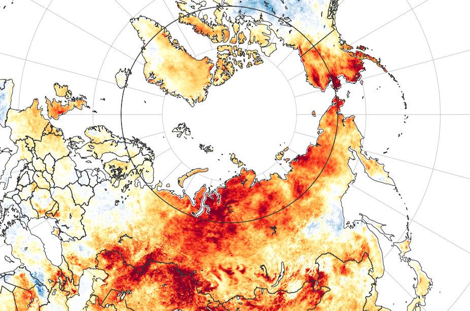
The Arctic heat wave that sent Siberian temperatures soaring to around 100 degrees Fahrenheit on the first day of summer put an exclamation point on an astonishing transformation of the Arctic environment that’s been underway for about 30 years.

As long ago as the 1890s, scientists predicted that increasing levels of carbon dioxide in the atmosphere would lead to a warming planet, particularly in the Arctic, where the loss of reflective snow and sea ice would further warm the region. Climate models have consistently pointed to “Arctic amplification” emerging as greenhouse gas concentrations increase.

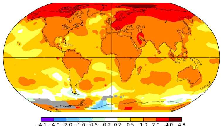
Well, Arctic amplification is now here in a big way. The Arctic is warming at roughly twice the rate of the globe as a whole. When extreme heat waves like this one strike, it stands out to everyone. Scientists are generally reluctant to say “We told you so,” but the record shows that we did.

As director of the National Snow and Ice Data Center and an Arctic climate scientist who first set foot in the far North in 1982, I’ve had a front-row seat to watch the transformation.

Arctic heat waves are happening more often – and getting stuck

Arctic heat waves now arrive on top of an already warmer planet, so they’re more frequent than they used to be.

Western Siberia recorded its hottest spring on record this year, according the EU’s Copernicus Earth Observation Program, and that unusual heat isn’t expected to end soon. The Arctic Climate Forum has forecast above-average temperatures across the majority of the Arctic through at least August.

Arctic temperatures have been rising faster than the global average. This map shows the average change in degrees Celsius from 1960 to 2019. NASA-GISS

Why is this heat wave sticking around? No one has a full answer yet, but we can look at the weather patterns around it.

As a rule, heat waves are related to unusual jet stream patterns, and the Siberian heat wave is no different. A persistent northward swing of the jet stream has placed the area under what meteorologists call a “ridge.” When the jet stream swings northward like this, it allows warmer air into the region, raising the surface temperature.

Some scientists expect rising global temperatures to influence the jet stream. The jet stream is driven by temperature contrasts. As the Arctic warms more quickly, these contrasts shrink, and the jet stream can slow.

Is that what we’re seeing right now? We don’t yet know.

Swiss cheese sea ice and feedback loops

We do know that we’re seeing significant effects from this heat wave, particularly in the early loss of sea ice.

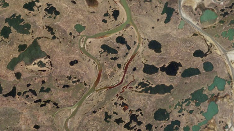
The ice along the shores of Siberia has the appearance of Swiss cheese right now in satellite images, with big areas of open water that would normally still be covered. The sea ice extent in the Laptev Sea, north of Russia, is the lowest recorded for this time of year since satellite observations began.

The loss of sea ice also affects the temperature, creating a feedback loop. Earth’s ice and snow cover reflect the Sun’s incoming energy, helping to keep the region cool. When that reflective cover is gone, the dark ocean and land absorb the heat, further raising the surface temperature.

Sea surface temperatures are already unusually high along parts of the Siberian Coast, and the warm ocean waters will lead to more melting.

The risks of thawing permafrost

On land, a big concern is warming permafrost – the perennially frozen ground that underlies most Arctic terrain.

When permafrost thaws under homes and bridges, infrastructure can sink, tilt and collapse. Alaskans have been contending with this for several years. Near Norilsk, Russia, thawing permafrost was blamed for an oil tank collapse in late May that spilled thousands of tons of oil into a river.

Thawing permafrost also creates a less obvious but even more damaging problem. When the ground thaws, microbes in the soil begin turning its organic matter into carbon dioxide and methane. Both are greenhouse gases that further warm the planet.

In a study published last year, researchers found that permafrost test sites around the world had warmed by nearly half a degree Fahrenheit on average over the decade from 2007 to 2016. The greatest increase was in Siberia, where some areas had warmed by 1.6 degrees. The current Siberian heat wave, especially if it continues, will regionally exacerbate that permafrost warming and thawing.

A satellite image shows the Norilsk oil spill flowing into neighboring rivers. The collapse of a giant fuel tank was blamed on thawing permafrost. Contains modified Copernicus Sentinel data 2020CC BY

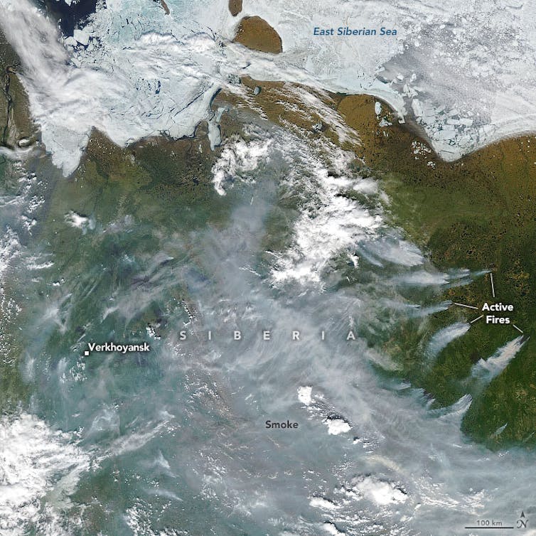
Wildfires are back again

The extreme warmth also raises the risk of wildfires, which radically change the landscape in other ways.

Drier forests are more prone to fires, often from lightning strikes. When forests burn, the dark, exposed soil left behind can absorb more heat and hasten warming.

We’ve seen a few years now of extreme forest fires across the Arctic. This year, some scientists have speculated that some of the Siberian fires that broke out last year may have continued to burn through the winter in peat bogs and reemerged.

A satellite images shows thinning sea ice in parts of the East Siberian and Laptev Seas and wildfire smoke pouring across Russia. The town of Verkhoyansk, normally known for being one of the coldest inhabited places on Earth, reported hitting 100 degrees on June 20. Joshua Stevens/NASA Earth Observatory

A disturbing pattern

The Siberian heat wave and its impacts will doubtless be widely studied. There will certainly be those eager to dismiss the event as just the result of an unusual persistent weather pattern.

Caution must always be exercised about reading too much into a single event – heat waves happen. But this is part of a disturbing pattern.

What is happening in the Arctic is very real and should serve as a warning to everyone who cares about the future of the planet as we know it.

***

Mark Serreze

100 degrees in Siberia? 5 ways the extreme Arctic heat wave follows a disturbing pattern

first published in “The Conversation” under a Creative Commons license

the compounding costs of California’s year-after-year wildfires

The compounding costs of California’s year-after-year wildfires are making it increasingly difficult for any party to absorb the expenses.

So observes Mark Cooper, Yale PhD, former Yale University and Fulbright Fellow, and Senior Research Fellow for Economic Analysis at the Institute for Energy and the Environment of Vermont Law School currently working on Energy Assessment.

PG&E electrical equipment, including power lines and poles, has been found to be responsible for at least 17 of 21 major Northern California fires of autumn 2017.

While the cause of California’s Camp Fire has not yet been determined, PG&E, one of California’s largest utilities, disclosed to the SEC on 9 November that an outage and damage to a transmission tower were reported in the area shortly before the fire started.

In the SEC Form 8-K of 9 November, PG&E declared that it may face billions of dollars in potential liabilities, far more than its insurance would cover, for the wildfires of 2018.

The Form 8-K reads, in pertinent part:

On November 8, 2018, a wildfire began near the city of Paradise, Butte County, California (the “Camp Fire”), located in the service territory of the Utility.  The California Department of Forestry and Fire Protection’s (“Cal Fire”) Camp Fire Incident Report dated November 13, 2018, 7:00 a.m. Pacific Time (the “incident report”), indicated that the Camp Fire had consumed 125,000 acres and was 30% contained.  Cal Fire estimates in the incident report that the Camp Fire will be fully contained on November 30, 2018.  In the incident report, Cal Fire reported 42 fatalities.  The incident report also indicates the following: structures threatened, 15,500; single residences destroyed, 6,522; single residences damaged, 75; multiple residences destroyed, 85; commercial structures destroyed, 260; commercial structures damaged, 32; and other minor structures destroyed, 772.

The cause of the Camp Fire is under investigation. On November 8, 2018, the Utility submitted an electric incident report to the California Public Utilities Commission (the “CPUC”) indicating that “on November 8, 2018 at approximately 0615 hours, PG&E experienced an outage on the Caribou-Palermo 115 kV Transmission line in Butte County. In the afternoon of November 8, PG&E observed by aerial patrol damage to a transmission tower on the Caribou-Palermo 115 kV Transmission line, approximately one mile north-east of the town of Pulga, in the area of the Camp Fire. This information is preliminary.” Also on November 8, 2018, acting governor Gavin Newsom issued an emergency proclamation for Butte County, due to the effect of the Camp Fire.

As previously reported, during the third quarter of 2018, PG&E Corporation and the Utility renewed their liability insurance coverage for wildfire events in an aggregate amount of approximately $1.4 billion for the period from August 1, 2018 through July 31, 2019. For more information about wildfire insurance and risks associated with wildfires, see PG&E Corporation and the Utility’s quarterly report on Form 10-Q for the quarter ended September 30, 2018.

While the cause of the Camp Fire is still under investigation, if the Utility’s equipment is determined to be the cause, the Utility could be subject to significant liability in excess of insurance coverage that would be expected to have a material impact on PG&E Corporation’s and the Utility’s financial condition, results of operations, liquidity, and cash flows.

United States Securities and Exchange Commission, Form 8-K, filed by PG&E on 9 November 2018

Citigroup estimates that PG&E’s exposure to liability for at least 17 of 21 major Norther California fires that took place in autumn 2017 is $15 billion. Citigroup estimates further that if it is found responsible for the Camp Fire, PG&E could face another $15 billion in claims. This number could rise, the fire is as yet only partially contained.

PG&E’s customers, both business and residential, may find themselves responsible for covering the bill for the company’s liabilities through higher costs.

California state  legislators took steps this year to shield PG&E and the state’s other investor-owned utilities from overwhelming legal claims, allowing them to pass the expense on to ratepayers.

California Senate Bill 901, signed into law on 21 September 2018, applies to fires beginning in 2019, and to some that occurred in 2017.

The bill enables utilities to sell bonds to cover liability costs and pay them off over time through higher rates.

(14) The existing restructuring of the electrical services industry provides for the issuance of rate reduction bonds by the California Infrastructure and Economic Development Bank for the recovery of transition costs, as defined, by electrical corporations. Existing law authorizes the PUC to issue financing orders, to support the issuance of recovery bonds, as defined, by the recovery corporation, as defined, secured by a dedicated rate component, to finance the unamortized balance of the regulatory asset awarded Pacific Gas and Electric Company in PUC Decision 03-12-035.

This bill would, under specific circumstances, authorize the PUC, upon application by an electrical corporation, to issue financing orders to support the issuance of recovery bonds to finance costs, in excess of insurance proceeds, incurred, or that are expected to be incurred, by an electrical corporation, excluding fines and penalties, related to wildfires, as provided.

SB 901, Dodd. Wildfires.

PG&E’s company shares dropped by more than 20 percent yesterday (Wednesday). More than half of its market value has been lost since late last week as the fires have spread.

Shares of other investor-owned utilities in California, Edison International (operated Southern California Edison) and Sempra Energy (owns San Diego Gas and Electric), dropped earlier this week.

California’s power supply is likely not to be at risk. PG&E could face bankruptcy if it cannot cover the liabilities it faces. Such a bankruptcy would eliminate shareholders’ equity and affect bondholder investments.

See:

California Utility Customers May Be on the Hook for Billions in Wildfire Damage,” Ivan Penn and Peter Eavis, The New York Times, 14 November 2018

SEC Form 8-K filed by PG&E, dated 9 November 2018

California Senate Bill No. 901

It’s your money ・ Hurricanes, flooding, fires. Buying a home?

It’s your money. ・ Hurricanes, flooding, wildfires. Buying a home? Approach your investment with care and due diligence.

Buying a home involves an enormous amount of money, and few people do it often enough to be experts. Given the realities of climate change, the process is now set against a backdrop of radical uncertainty about the very ground you will live on and the air you will breathe.

Given all that, you owe it to yourself to call on every dispassionate expert you can find and grab all available data on any risk you are taking on.”

There is a case for optimism here, where the world comes together and manages to turn the (rising) tides. So if you are a positive thinker or can afford a big loss, by all means bet one of your biggest assets on that possibility.

Otherwise, ask yourself this: Just how much more science and weather will it take before ever larger numbers of people decide to settle in or retire to places that pose less risk? And once they do, do you want to be trying to unload your property in a danger zone so you can afford to join them?

You’re Buying a Home? Have You Considered Climate Change?”, Ron Lieber, The New York Times, 2 December 2016

Research and understand highly pertinent issues such as those that follow below. Examine flood zones, flood insurance, fire zones, and the term Wildland Urban Interface (WUI, indexes the conversion of wildland to developed territory).

In the context of wildfires, a cornerstone of risk evaluation is a metric called the Wildland Urban Interface, or WUI. WUI indexes the conversion of wildland to developed territory. WUI indicates an explosion in wildland development over recent years.

According to the Wildland Urban Interface (WUI) measurement framework, the conversion rate from wildlands to urban development has grown to 4,000 acres per day or close to 2 million acres per year.

The explosion in WUI development increasingly puts homeowners, firefighters and communities at risk of wildfire – a risk that is only growing across the United States as the globe warms and aridification worsens. Since the 1980s, large fires in Northern California have increased by 60 percent. Some forests in the Pacific Northwest have seen a 5,000 percent increase in annual burned land

According to the  2017 Verisk Wildfire Risk Analysis, more than 2 million of the 4.5 million homes at high or extreme risk of wildfire are in California.

We should start by learning which regions are most at risk. Many people assume that most WUI lands fall in the western states. The large eastern and southern states have the most land in the WUI. In 2016, Kansas and Oklahome saw over a million acres burn – that’s an area bigger than the state of Rhode Island. 

The so-called “fire season” has continued to lengthen over the past several decades, and that, since 2000, climate change has been attributed to adding 9 additional days of high fire season. The environmental context facing designers and developers is thus increasingly risky.

We Should Plan Homes to Minimize the Threat of Wildfires,” Jesse M. Keenan and Alice Hill, Newsweek, 21 October 2017

Services & infrastructure

Sources & uses of municipal services such as flood- and fire-prevention, -recovery, and related maintenance services.

How much does the locality (village, town, county, parish, state) pay for public services such as roads, pumps, fire services, drinking water, sewage, etc. Where does the money come from. 

Sources & uses of flood- and fire-prevention and -recovery service funds

How are flood- and fire-prevention and -recovery services financed and funded. How long will flood- and fire-prevention and -recovery services be affordable. How is “affordable” defined.

Home-purchase finance

If you plan to finance a purchase with a mortgage, examine how banks and insurance companies are currently managing flood- and fire-prone properties in their portfolios. What are the trend lines? What steps are being taken by banks and insurance companies vis a vis such properties to protect their balance sheets over the long term.

Insurance

Examine how insurance companies are managing flood- and fire-prone properties in their portfolios. What are the trend lines? What steps are being taken by insurance companies vis a vis such properties to protect their balance sheets over the long term.

What are current premiums? Is the appropriate insurance provided by private companies, by the government? How much will you receive in case of a disaster? Will you receive the full market value of the damaged property?

Sources & uses of energy

Energy matters. Know sources and uses of energy. A house designed and built for low energy unit intensity offers multiple advantages.

Sources, uses, costs, & quality of water

Water matters. Know sources, uses, costs, and quality of water.

Building materials

Building materials and construction matter. Know how and of what materials the house is constructed. Is the house built for fire resilience? Is the house built for flood resilience?

Access & transportation infrastructure

Access matters. How is the neighborhood served by transportation. Can you get to work / school / the doctor’s and dentist’s office / the grocery store and shops / all those important places by foot, bike, bus, train? Must you drive a car? (Think of the CO2 emissions that are exacerbating both the floods and the fires.) Are there multiple lines of access? One road?

Climate change

Research climate change and its effects in your geographical area of interest.

A team & teamwork matter

Develop a team of experts, whom you can trust and consult and with whom you can work together, in your geographical area of interest.

As you delve into these questions, here are links to articles, and there are many more, that provide information, insight, perspective and links to further sources of information.

See:

You’re Buying a Home? Have You Considered Climate Change?”, Ron Lieber, Your Money | The New York Times, 2 December 2016

Flooding Risk Knocks $7 Billion Off Home Values, Study Finds,” Laura Kusisto, The Wall Street Journal, 25 August 2018

Your coastal property has already lost value to sea rise. This site can tell you how much”, Alex Harris, Miami Herald, 25 July 2018

Fire Weather Outlooks (updated daily), NOAA’s National Weather Service Storm Prediction Center, Fire Weather Outlooks

Why does California have so many wildfires?”, Kendra Pierre-Louis, The New York Times, 9 November 2018

Forced Out by Deadly Fires, Then Trapped in Traffic,” Jack Nicas, Thomas Fuller, Tim Arango, The New York Times, 11 November 2018

Jesse M. Keenan in Newsweek: time is now to evaluate design risk, enhance resilience against wildfires,” Travis Dagenais, Harvard University Graduate School of Design, 24 October 2017

We Should Plan Homes to Minimize the Threat of Wildfires,” Jesse M. Keenan and Alice Hill, Newsweek, 21 October 2017

North Carolina, Warned of Rising Seas, Chose to Favor Development,” John Schwartz and Richard Fausset, The New York Times, 12 September 2018

Perils of Climate Change Could Swamp Coastal Real Estate,” Ian Urbina, The New York Times, 24 November 2016

Underwater. Rising Seas, Chronic Floods, and the Implications for US Coastal Real Estate,” Union of Concerned Scientists, 2018

Del Mar stands firm against ‘planned retreat”, Phil Diehl, The San Diego Union-Tribune, 22 May 2018

Can Miami Beach survive global warming?”, David Kamp, Vanity Fair, 10 November 2015

Rising seas, distressed communities, and ‘climate gentrification’: Jesse M. Keenan talks Miami in Vice, Scientific American,” Travis Dagenais, Harvard University Graduate School of Design, 14 August 2017

California Today: Now Comes the Insurance Challenge,” Mike McPhate, The New York Times, 11 October 2017

Climate change and commercial real estate: How resilient is your portfolio?” Jeffrey Kanne, Carlos Madex-Madani, Sam Bendix, Institutional Real Estate, Inc., 1 June 2017

Settling post-catastrophe insurance claims: What agents should know,” Bernice Ross, Inman, 5 September 2017

High Ground Is Becoming Hot Property as Sea Level Rises,” Erika Bolstad, Scientific American, 1 May 2017

Wildland-Urban Interface: Key Issues,” L. Annie Hermansen-Báez, Jennifer Seitz, and Martha C. Monroe, Joint product of InterfaceSouth of the Centers for Urban and Interface Forestry, Southern Research Station, U.S. Forest Service and the University of Florida, Institute of Food and Agricultural Sciences (IFAS). Published March 2009.

Key findings from the 2017 Verisk wildfire risk analysis,” Arindam Samanta, Verisk, 12 July 2017

The Wildland-Urban Interface in the United States,” Susan I. Stewart, Northern Research Station, USDA Forest Service, Evanston, IL (sistewart@fs.fed.us), Volker C. Radeloff, Department of Forestry, University of Wisconsin-Madison, Roger B. Hammer, Department of Sociology, Oregon State University